


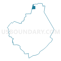
Voting District 0050, Brazoria County, Texas
About
Outline

Summary
| Unique Area Identifier | 671076 |
| Name | Voting District 0050 |
| County | Brazoria County |
| State | Texas |
| Area (square miles) | 10.05 |
| Land Area (square miles) | 9.93 |
| Water Area (square miles) | 0.12 |
| % of Land Area | 98.77 |
| % of Water Area | 1.23 |
| Latitude of the Internal Point | 29.53718580 |
| Longtitude of the Internal Point | -95.41136820 |
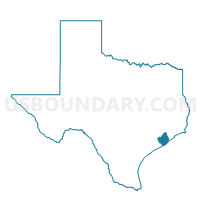
Maps

Graphs
Select a template below for downloading or customizing gragh for Voting District 0050, Brazoria County, Texas


Neighbors
Neighoring Voting District (by Name) Neighboring Voting District on the Map
- Voting District 0021, Brazoria County, TX
- Voting District 0029, Brazoria County, TX
- Voting District 0040, Brazoria County, TX
- Voting District 0058, Brazoria County, TX
- Voting District 0059, Brazoria County, TX
- Voting District 0131, Harris County, TX
- Voting District 1003, Fort Bend County, TX
- Voting District 1134, Fort Bend County, TX
Top 10 Neighboring County Subdivision (by Population) Neighboring County Subdivision on the Map
- Houston CCD, Harris County, TX (3,075,388)
- Alvin-Pearland CCD, Brazoria County, TX (176,301)
- Stafford-Missouri City CCD, Fort Bend County, TX (131,732)
Top 10 Neighboring Place (by Population) Neighboring Place on the Map
Top 10 Neighboring Unified School District (by Population) Neighboring Unified School District on the Map
- Houston Independent School District, TX (1,312,684)
- Fort Bend Independent School District, TX (348,526)
- Alvin Independent School District, TX (86,711)
Top 10 Neighboring State Legislative District Lower Chamber (by Population) Neighboring State Legislative District Lower Chamber on the Map
- State House District 27, TX (225,449)
- State House District 29, TX (208,164)
- State House District 131, TX (152,889)
Top 10 Neighboring State Legislative District Upper Chamber (by Population) Neighboring State Legislative District Upper Chamber on the Map
Top 10 Neighboring 111th Congressional District (by Population) Neighboring 111th Congressional District on the Map
- Congressional District 22, TX (910,877)
- Congressional District 14, TX (779,704)
- Congressional District 9, TX (733,796)
Top 10 Neighboring Census Tract (by Population) Neighboring Census Tract on the Map
- Census Tract 6606.02, Brazoria County, TX (26,843)
- Census Tract 6607.01, Brazoria County, TX (15,452)
- Census Tract 6708, Fort Bend County, TX (14,354)
- Census Tract 6606.01, Brazoria County, TX (11,893)
- Census Tract 6607.02, Brazoria County, TX (11,664)
- Census Tract 3308, Harris County, TX (8,571)
- Census Tract 6707, Fort Bend County, TX (3,382)